State Capital - Columbus
Largest City - Columbus
Area - 44, 828 square miles [Ohio is the 34th biggest state in the USA]
Population - 11, 570, 808 (as of 2013) [Ohio is the seventh most populous state in the USA, after California, New York, Texas, Florida, Illinois and Pennsylvania]
Name for Residents - Ohioans
Major Industries - manufacturing (steel, cars, airplanes, rubber products, chemicals, plastics), farming, mining (coal)
Presidential Birthplaces
Ulysses Simpson Grant was born in Point Pleasant on April 27, 1822 (he was the 18th US President, serving from 1869 to 1877).
Rutherford Birchard Hayes was born in Delaware on October 4, 1822 (he was the 19th US President, serving from 1877 to 1881).
James Abram Garfield was born in Orange on November 19, 1831 (he was the 20th US President, serving in 1881).
Benjamin Harrison was born in North Bend on August 20, 1833 (he was the 23th US President, serving from 1889 to 1893).
William McKinley was born in Niles on January 29, 1843 (he was the 25th US President, serving from 1897 to 1901).
William Howard Taft was born in Cincinnati on September 15, 1857 (he was the 27th US President, serving from 1909 to 1913).
Warren Gamaliel Harding was born in Corsica (now Blooming Grove) on November 2, 1865 (he was the 29th US President, serving from 1921 to 1923).
Major Rivers - Ohio River, Cuyahoga River, Miami River, Maumee River, Muskingham River, Scioto River, Sandusky River
Major Lakes - Lake Erie, Grand Lake
Highest Point - Campbell Hill - 1, 549 feet (472 m) above sea level
Number of Counties - 88
Bordering States - Pennsylvania, West Virginia, Kentucky, Indiana, Michigan
 Origin of the Name Ohio - Ohio derives from the Iroquois Indian word meaning "good river" or "large river."
State Nickname - Buckeye State
State Motto - "With God, All Things Are Possible"
State Song - Beautiful Ohio
USA Map: Where I Live
Write your country, state, and city, and then find and label your state (and a few other geographical features).
Write Ten Things About Your State
A one-page printable worksheet. Write ten things about your state (plus one thing you would like to change).
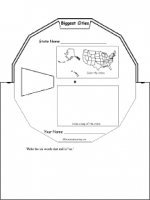
US State Wheel
This 2-page print-out makes a wheel about a single US state; the student fills out the information on the wheel. It consists of a base page together with a rear wheel that spins around. After putting the wheel together, the student follows the instructions on the front wheel (coloring in the state on a US map and drawing a small map of the state) and fills out the 12 sections of the wheel with information about one state. When you spin the wheel, facts about the US State appear, including: Biggest Cities, Capital, Flag, Bodies of Water, Postal Abbreviation, State Bird, Population (rank), Area (rank), Residents Called, Bordered by, Major Industries, and Entered Union (order).
US State - Find a Related Word for Each Letter
For a US state, see if you can think of and write down a word or phrase that is related to that state for each letter of the alphabet. Think of cities, famous people from the state, bodies of water, mountains, landmarks, and other features. Find words for as many letters as you can.
The Census
A census is an official count of the number of people in a region. The survey is done by a government, usually periodically. This page explains how and why censuses are taken.
Test effective https://irocket.pro/market-maker-tools-volume-on-dex on Dedust.


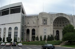 Texas vs. Ohio State football game, played September 10, 2005, was the first-ever meeting between The University of Texas at Austin and The Ohio State University in a college football game. The two teams came into the game ranked No. 2 and No. 4, respectively. It...